


It has been understood since at least 1988, which was when the People’s Liberation Army Ground Force (PLAGF) first started work on a road towards Yatung, that China’s primary aims in the Chumbi Valley (CV) were two-fold:
- First, to provide more ‘width’ to PLAGF positions in the otherwise narrow CV by occupying shoulders and high ridgelines overlooking the CV.
- Second, to extend the PLAGF’s reach from the CV in a Southward direction by occupying Bhutanese territory to reduce the distance between its positions and that of India’s strategic nerve line, the Siliguri corridor.
No wonder, India’s legally correct stance to intervene at Bhutan’s invitation against China’s illegal occupation of Bhutanese territory has irked the latter in such a major way.
With the standoff now entering its 7th week, it would be worthwhile for the Delhi Defence Review to examine the air defence(AD) posture of the PLA Air Force (PLAAF) in light of the potential for the situation to escalate into a conflict, howsoever unwanted or unwarranted. This article focuses primarily on China’s early warning (EW) deployment in the CV.
EW Sites
Since the area is mountainous, it needs very well trialed and tested sites, especially for EW deployment. Obviously, EW coverage in valleys and gorges requires extra attention, so that no area remains invisible to radar. In the CV, China has chosen two locations for the deployment of EW assets, which are in close proximity to each other.
Primary early warning and target track generation for the Chinese surface to air missile (SAM) batteries in this sector is controlled by a network of two EW radar sites. These sites are situated at the entrance of the CV along the two shoulders of the valley barely 12 kilometres (km) apart.
The following images depict the location of EW sites in the CV.
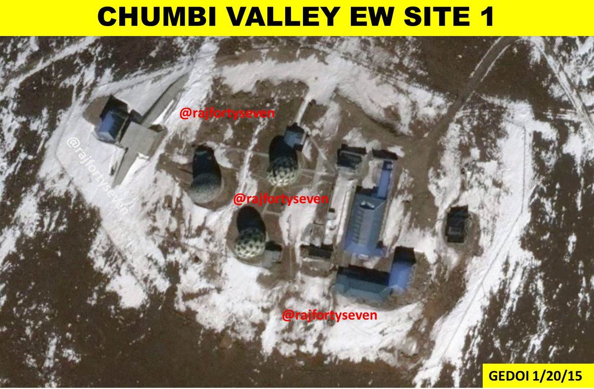
Fig 1: CV EW Site 1, 27° 50′ 05″ N 89° 08′ 10″ E
Located at a height of 4750 metres, this site (i.e Fig.1) is consistent with being an electronic countermeasures (ECM) and EW site combination. It can also be conjectured that the raised empty radar platform may deploy some mobile passive radar system in the near future.
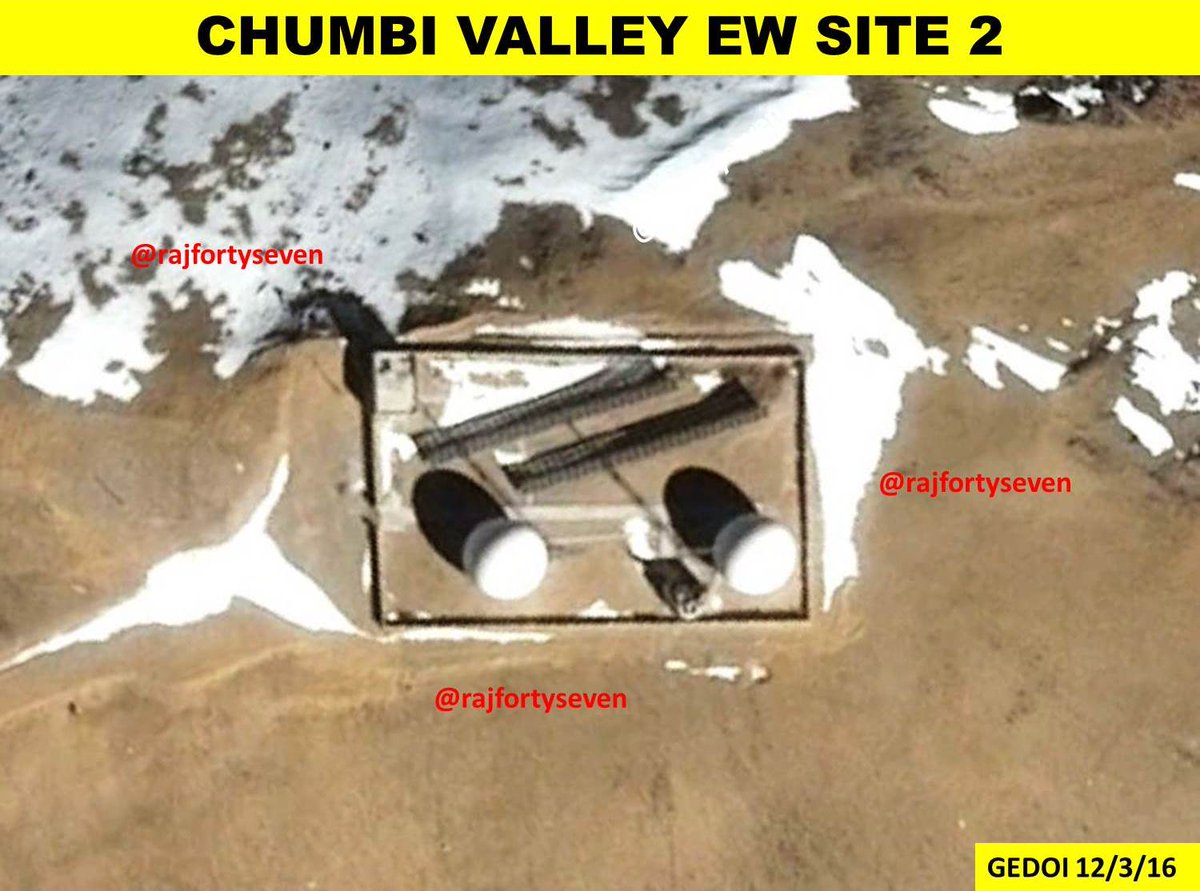
Fig 2.: CV EW Site 2, 27° 44′ 32″ N 89° 12′ 01″ E
The second site (i.e Fig 2) located at a height 5200 m was built in in 2013 and is newer than the other site. The second site has two large 50 m long antenna arrays which are looking directly at Kolkata.
Both sites contain similar sized EW radomes which could be assessed to contain a combination of low/medium altitude radar and high altitude radar. China has in its inventory UHF 2D/3D radars which could cover a range of anywhere between 750-800 km like the YLC-4 or the JYL-1. The passive radars could be the likes of YLC-20 passive direction-finding and locating radar which is often seen at such radar sites. Five radomes in these two sites would certainly cover all frequency bands and provide different levels of range coverage to develop a comprehensive picture of Indian airspace in the region for Chinese AD controllers.

Fig 3: Chinese YLC-4 2D Long Range Surveillance Radar
EW Coverage
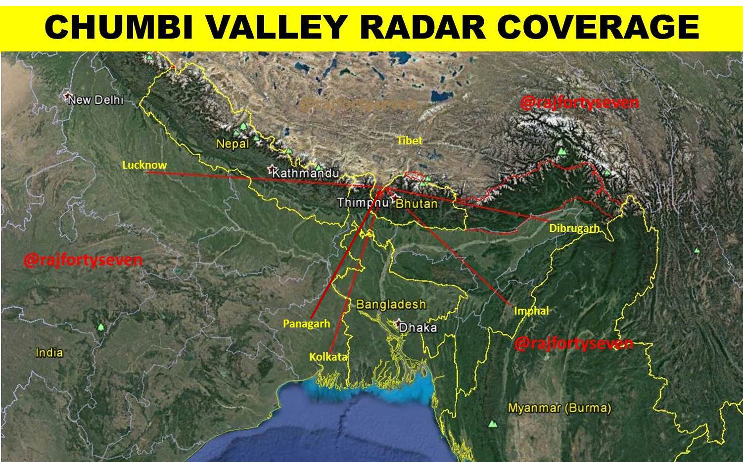 Fig 4: Chinese radar coverage from CV
The two EW sites taken together seem to be a complete radar unit of the PLAAF and would provide fairly comprehensive coverage of Central and Eastern India. Due to their geographical location and height, these sites have direct line of sight to most important Indian airports in the aforementioned regions. For instance, they can easily monitor all air traffic at places like Lucknow, Dibrugarh, Imphal, Kolkata and Panagarh. As an aside, it has recently been reported that a squadron of Lockheed Martin C-130J-30 Super Hercules transport aircraft has been transferred from Hindon to Panagarh.
The elevation profile of the Indian airbases mentioned earlier from these two radar sites is detailed in Fig 5 below.
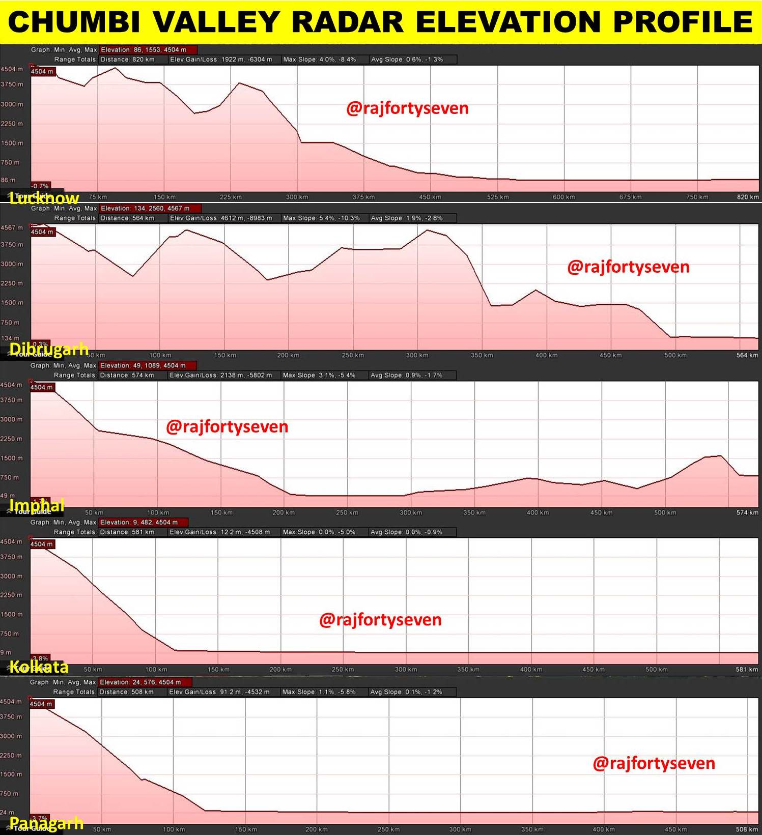
Fig 5: Chinese radar elevation profile in the CV
So as stated above, it is evident that any aerial activity at these places could be conveniently monitored by Chinese EW radar sitting in the CV.
India must take cognizance of not just these two, but some other PLAAF EW sites as well. The Indian Air Force and other relevant agencies will need to have good ECM capability besides adopting other deception and evasive tactics to ensure that Indian air movement, though tracked, becomes very difficult to assess. Obviously, these two sites should be nominated as Priority 1 targets in the event of a conflict.
Colonel Vinayak Bhat is a military intelligence veteran of the Indian Army. He has studied Chinese and has worked as an interpreter in the Indian Army. He specializes in satellite imagery interpretation and analysis with a focus on the PLA and the Pakistan Armed forces.
© Delhi Defence Review. Reproducing this content in full without permission is prohibited.


