


The recent uncontrolled reentry of China’s first space station module, Tiangong 1, once again brought to the fore the need for India to augment its limited space situational awareness (SSA) capabilities. While the United States (US) and China were able to predict Tiangong 1’s reentry trajectory fairly accurately, absent were Indian contributions towards real-time reentry predictions for the Tiangong 1’s final moments. Despite being a member of the 13-nation Inter-Agency Debris Committee (IADC) that selected Tiangong 1’s reentry mission for its joint annual re-entry test campaign, and contributing towards early predictions of its re-entry window, India’s lack of participation in real-time tracking of Tiangong 1’s re-entry could be largely attributed to its lack of a substantive SSA architecture. However, given that space is becoming ever crowded with a concomitant rise in India’s own space-based asset pool, continued dependence only on low-accuracy foreign sources for SSA would be imprudent.
Before we delve into India’s options for improving the current state of affairs with respect to SSA, it would be worthwhile to take a quick look at the Tiangong 1 reentry episode and what it revealed about extant SSA capabilities around the world.
A brief history
On 29 September 2011, China launched its first Space Station module- Tiangong 1. The module was launched on a Long March 2F rocket and weighed about 8.5 tonnes. At 10.5 m long, with a diameter of 3.3m, Tiangong 1 was China’s first step towards building a permanent space station in space. The name Tiangong translates to ‘Heavenly Palace’ in English.
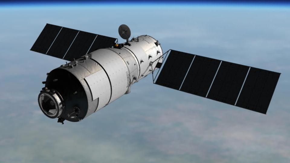
Image: Tiangong 1, while it was still in space. Source: CMSA
Placed at an average altitude of 360 km, the space station consisted of a resource module that contained propellant tanks and rocket engines to supply the power necessary for flight, a transition section and an experimental module.[1] Tiangong 1 was originally expected to stay in orbit for two years. During the two years, the space station was used for testing rendezvous and docking techniques with three Shenzou spacecrafts. Shenzou 8, launched in 2011, was an unmanned version of the missions that would carry Chinese astronauts, known as Taikonauts. A total of six Taikonauts have been on-board the Tiangong 1 in the Shenzou 9 and Shenzou 10 missions that followed in 2012 and 2013 respectively.
Though the mission was to end in 2013, China decided to extend it to 2016. During its extended flight period Tiangong 1 conducted experiments on space technology, space-earth remote sensing and space environment exploration.[2] Towards the end of its mission in 2016, China lost telemetry with the station.
Without control, the space station began losing its orbit and it was inevitable that Tiangong 1 would re-enter the atmosphere in the following two years. There was appreciable interest among the astronomer community to predict the time and location of re-entry of the space station.
On September 14, 2016 in an official statement, China predicted Tiangong 1 to fall back to the earth in the latter half of 2017. An update on this prediction was issued in December 2017 by the Permanent Mission of China to the United Nations where the Space Station’s re-entry window was predicted to fall between the first 10 days of February and the last 10 days of March 2018.[3] Since then, various organizations had begun following the descent of the prototype space station.
Current Global SSA capabilities
Space today is overcrowded. As of 25 April 2018, there are 43, 435[4]objects in space comprising both active satellites, non-functional satellites, spent upper stages and debris. There have been accidental and intentional collisions in space and it becomes important to keep track of space objects and maneuver one’s satellite at times to avoid collision with a defunct space object.
It is therefore, important to track all the objects (active satellites, defunct satellites and other debris) orbiting the Earth. It becomes all the more important to possess capabilities to track objects in space – both large and small. Large objects like Tiangong 1 provide unique opportunity for studying their orbital decay and re-entry phase of flight.
Currently, the U.S maintains the most complete catalogue of space objects. It boasts of widespread network of ground-based radars and optical telescopes across the globe to track objects in space. According to the U.S Department of Defense, a potential of 375 sensors are available for SSA across the civil, military, commercial and intelligence communities. The ground-based sensors are complemented by several space-based space surveillance systems. The data collected from this network, known as the U.S Space Surveillance Network (SSN), is processed by the Joint Space Operations Centre (JSpOC) and there, the 18th Space Control Squadron maintains a database of the orbital trajectories of more than 23,000 space objects.
After U.S, Russia has the second most capable network of ground-based radars and optical telescopes. Like the U.S, the Russian space surveillance system too is largely derived from their missile early warning systems.
Similarly, China too has satellite tracking radars and optical sensors. However, China lacks coverage outside its borders. They also have space-based space surveillance capabilities. The European Space Agency, Japan and Australia also have Space Situational Awareness capabilities.
Apart from these, several private firms across the globe offer commercial SSA data services either based on the data available from the U.S Space Track website or by using their own network of telescopes and radars around the world. Along with this, the tracking capabilities of the amateur astronomer community too is not trivial and therefore merits attention.
Tracking Tiangong 1
The orbital decay and reentry of Tiangong provided a unique opportunity for researchers and space agencies to predict the reentry and possible impact zones.
The U.S SSN was the main source of data during Tiangong 1’s re-entry. Apart from the Joint Force Space Component Command (JFSCC) of the US Strategic Command (USSTRATCOM), Aerospace Corporation, an organization based in California, U.S.A, made predictions regarding Tiangong 1’s re-entry based on the Two Line Elements (TLS) put out by the USTRATCOM on their Space-Track website.
In early 2018, the IADC consisting of 13-member states selected Tiangong 1’s reentry mission for its joint annual re-entry test campaign. In this campaign, experts from 13-member states including NASA, ESA, China, Japan, India, Russia and South Korea pooled their predictions of the re-entry time window based on the tracking data obtained from their own radars and other sources. The aim of the campaign was to improve the prediction accuracy for all members through cross- verification and cross-analysis. The ESA served as the host and administrator for the campaign.
In addition to the IADC campaign, ESA’s Space Debris office generated its own independent predictions with the help of data collected from European radars and telescopes on ground.
Accuracy of Re-entry Predictions
Tiangong 1 re-entered the earth’s atmosphere over the South Pacific Ocean at approximately 5.16 pm (PST) or 00:16 am UTC on 2nd April 2018. The Re-entry mission was largely tracked by US STRATCOM (JFSCC), ESA, Aerospace Corp., IADC and China. Table 1. gives the prediction details of Tiangong 1 by US STRATCOM, ESA and Aerospace Corporation.
Table 1: Re-entry Predictions
| Source | Date of Prediction | Predicted Re-entry Date
UTC |
| US STRATCOM | 01-Apr-2018
(18:30 UTC) |
2 Apr, 00:48 (±02 hours) |
| ESA | 01-Apr-2018
(21h UTC) |
2 Apr, 01:00 (±02 hours) |
| Aerospace Corp. | 01-April-2018
(20:30 UTC) |
2 Apr, 00:30 (±1.7 hours) |
Source: SATFLARE http://www.satflare.com/track.asp?q=37820#TOP
Since Tiangong-1’s reentry was uncontrolled, initially only a large window for the exact time and place of re-entry could be predicted. Predictions became more accurate as the re-entry time approached closer. It is to be noted that the predictions made by all the organisations were fairly accurate, especially by the Chinese.
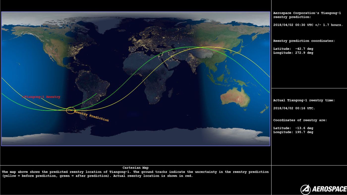
Image: Predicted re-entry location of Tiangong-1
The U.S and China were able to give the precise time for the spacecraft’s burn up. The U.S Air Force operates a constellation of four Space Based Infra-Red (SBIR) satellites in the Geosynchronous Earth Orbit (GEO). The SBIR is a space based early missile warning system. China too has a similar infrared sensor satellite also used for early missile warning in the GEO. These satellites use their infra-red sensors to detect heat from missiles or booster plumes. Similarly, these satellites are also capable of detecting heat signatures produced by forest fires on the Earth as well as the heat produced by a spacecraft during its atmospheric re-entry. It is believed that U.S and China relied on these Space based Infra-red early missile warning satellites to refine Tiangong 1’s re-entry prediction time.[5]
Tiangong 1 Re-entry Predictions: Takeaways for India
It is important to note that Tiangong 1’s re-entry was uncontrolled and even though the space station fell into the South Pacific Ocean, North West of Tahiti, it missed the ‘spacecraft graveyard’[6] which is further south, about 3900 Km southeast of Wellington in New Zealand. While all the organisations could make accurate predictions of Tiangong 1’s re-entry time window, the precise location of where it would fall could not be determined until the final minutes of its atmospheric reentry.
The predictions made by the different organisations, including ESA, were largely based on US SSN data. While India did participate in the IADC campaign in February 2018, India’s role and contributions towards the real-time re-entry predictions during Tiangong 1’s final moments were missing. One of the major reasons for India to be missing from the main picture during Tiangong 1’s re-entry predictions is the absence of an independent Space Situational Awareness system in place.
Like several other countries, India continues to depend on the Two Line Elements (TLE) put out by the 18th Space Control Squadron of the U.S Air Force. The orbital parameters derived from the TLEs and other data like mass of the satellite can be used to deduce the application and purpose of a satellite. However, India’s continued dependence on foreign sources for SSA data and the limitations arising from the unavailability of high accuracy data in the public domain, underscores the need for:
- Access to high accuracy data
- Preferably an independent/ complementary capability of tracking debris and satellites.
Events like Tiangong 1’s re-entry provide a good opportunity for countries and other organisations that track space objects to hone their tracking capabilities and data analysis to make precise predictions.
Tiangong 1 was not the largest object in space. The International Space Station, completed in 2011 in LEO, continues to evolve to include new experiments. Presently, the space station will continue to operate till 2024 and discussions for a possible extension till 2028 are underway. Simultaneously, cost reductions and increase in the accessibility to space is encouraging private players to invest in space. The future will see similar public-private partnership space station projects.
In the past decade, there has been an exponential increase in the number of space missions and activities across the world. Space is rapidly getting congested, contested and conflicted. The happenings in space have the potential to trigger geopolitical tensions and conflicts on Earth. While the US Space Objects Catalogue is currently considered to be the most complete catalogue, the US Space Surveillance Network lacks coverage in the Southern Hemisphere. To ensure the security and safety of its space assets, it is, therefore, important for India to evolve an independent mechanism to monitor activities in space on a regular basis.
Presently, India’s tracking capabilities are restricted only to the Lower Earth Orbit (LEO) with the Multi Object Tracking Radar (MOTR) that is capable of tracking objects upto 1000km.
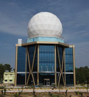
Image: The Multi Object Tracking Radar in SDSC, Shiharikota. Source: ISRO
Way Forward
Developing a robust, independent SSA capability requires 1) Good geographical distribution of ground-based sensors (radars and optical telescopes) 2) An effective space based SSA capability that complements the ground-based sensors and 3) Capability to analyse SSA data gathered from these sensors.
Now even as India moves towards putting in place wide-ranging SSA infrastructure, it could in the meantime pursue the following options to augment its ability to observe the heavens, as it were:
1. Cooperation agreements with other countries: India can help fill the existing gap in the global SSA network. The possibility of an India-Australia-Japan network can be explored to provide coverage in the Southern and Eastern hemisphere.
2. Access to High Accuracy data for SSA: Currently U. S’s low accuracy space catalogue (stored in the form of TLEs) is made available to all registered users on the Space Track website which currently contains information on more than 23,000 man-made objects in space. Access to the high accuracy catalogue can only be obtained by entering into a formal agreement with USSTRATCOM (U.S Strategic Command). The feasibility of entering into a formal agreement with the U.S. can be explored.
Apart from the USSTRATCOM, there are a number of private players that maintain their own Space Catalogues and offer SSA services. India can explore the option of buying services and data from such organizations to increase the accuracy of its predictions and conjunction analyses.
3. Recommissioning Available Telescopes for SSA: The Indian Institute of Astrophysics operates and maintains several optical telescopes on the Indian mainland. While these optical telescopes are primarily used for astronomical purposes, their capabilities can be augmented for tracking and observing space objects in LEO as well as GEO.
As mentioned earlier, India possesses the MOTR that can track objects in space upto a range of 1000 kms. Several more of these radars could be deployed across the country to increase tracking capability.
4. Space Based Space Surveillance: To complement the limited ground-based sensor capabilities, it would be economically prudent for India to base its SSA capability on space based SSA systems. Presently, India has adequate satellite building and launching capability that can be harnessed to develop an effective space based SSA system.
5. Promoting the role of amateur astronomer community in SSA: Elsewhere in the world the role of amateur astronomers has been commendable in tracking space objects. These astronomers have demonstrated their abilities to routinely track classified spacecrafts from several countries. Recognizing this potential, the ESA is now turning to amateur astronomers to crowdsource their observations to build their space catalogue.
India too has a large community of amateur astronomers and satellite observers whose capabilities can be used and further augmented for SSA purposes. In order to harness these capabilities, it is important for India to develop a strong and knowledgeable base of satellite observers by encouraging participation of space enthusiasts and amateur astronomers in tracking and prediction exercises of events like the Tiangong 1’s reentry mission.
Mrunalini Deshpande is a Senior Research Fellow in the International Strategic and Security Studies Programme at the National Institute of Advance Studies (NIAS), Bangalore. She acknowledges Prof. Rajaram Nagappa, Head of International Strategic and Security Studies Programme, NIAS and Prof. Lalitha Sundaresan, Visiting Professor, NIAS for their valuable inputs and suggestions for this piece.
References
- Tiangong 1 Spacecraft Overview, Spaceflight 101.com, http://spaceflight101.com/spacecraft/tiangong-1/ (Accessed on April 22, 2018) ↑
- China’s 1st space lab Tiangong-1 ends data service, Xinhuanet, March 21, 2018, http://www.xinhuanet.com/english/2016-03/21/c_135209671.htm ↑
- Note verbale dated 8 December 2017 from the Permanent Mission of China to the United Nations (Vienna) addressed to the Secretary-General, United Nations General Assembly, Committee on Peaceful Uses of Outer Space, December 12, 2017, http://www.unoosa.org/res/oosadoc/data/documents/2017/aac_105/aac_1051150add_1_0_html/V1708786E.pdf ↑
- SATCAT Boxscore, Celestrack website, https://www.celestrak.com/satcat/boxscore.asp (Accessed on April 24, 2018) ↑
- How Was China’s Tiangong-1 Space Station Crash Tracked So Accurately?, by Sarah Lewin, Space.com, April 02, 2018, https://www.space.com/40168-china-space-station-tiangong-1-crash-tracking.html (Accessed on April 24, 2018) ↑
- “Spacecraft graveyard” is a place on Earth where spacecrafts are dropped off at the end of their operational lives. The area is chosen so as to not endanger any human or oceanic life as it is an area of ocean that is furthest from land. ↑
© Delhi Defence Review. Reproducing this content in full without permission is prohibited.


